Links to Useful Resources for Neighbourhood Planning
Community Questionnaire
A Community Questionnaire about the Drayton 2020 Neighbourhood Plan was delivered to each household in Drayton in July 2013 and collected back in August. There was a response rate of 62%.
The returns were analysed by Oxfordshire Rural Community Council and their Report Appendix of extra comments made.
Village Plans
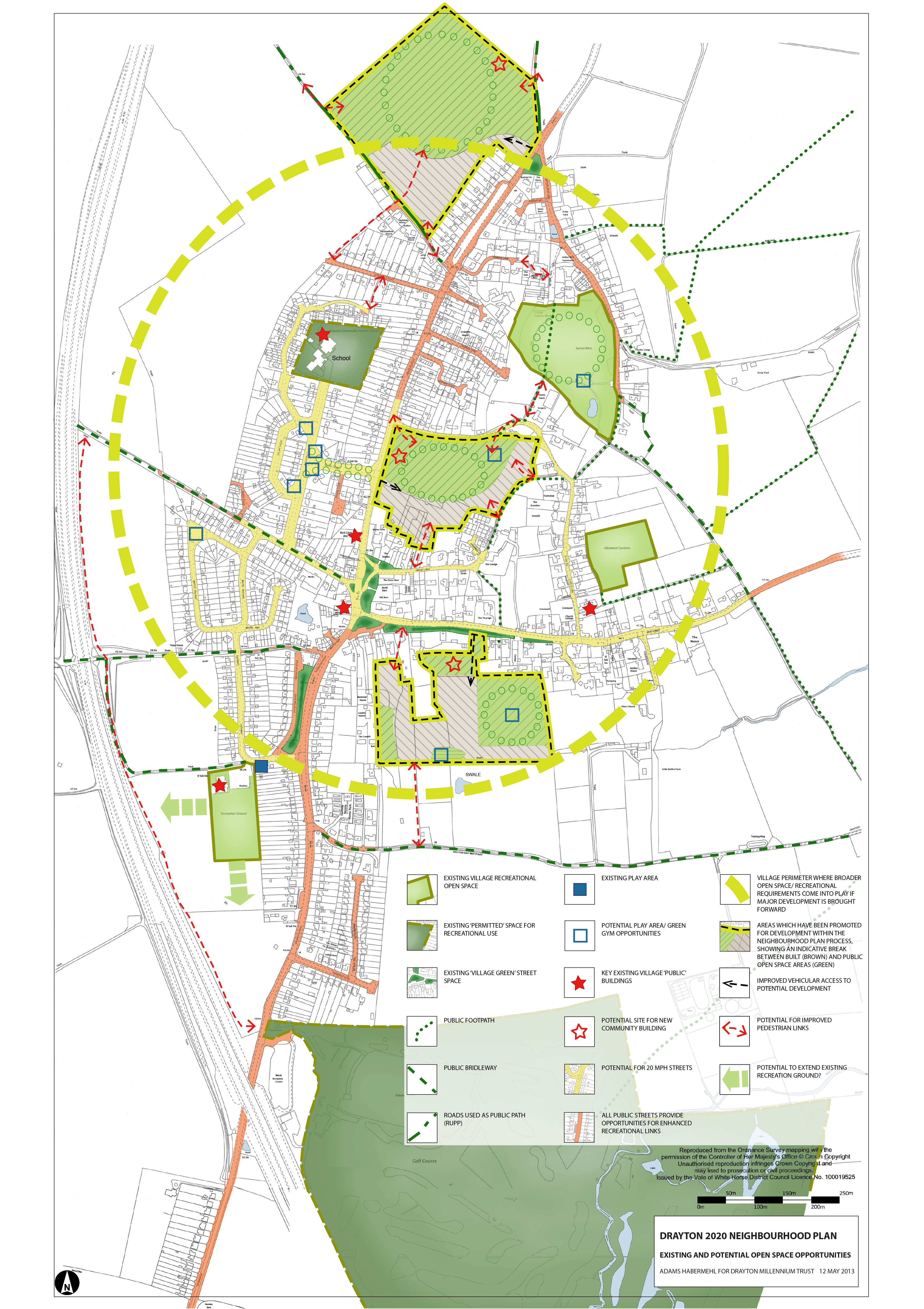
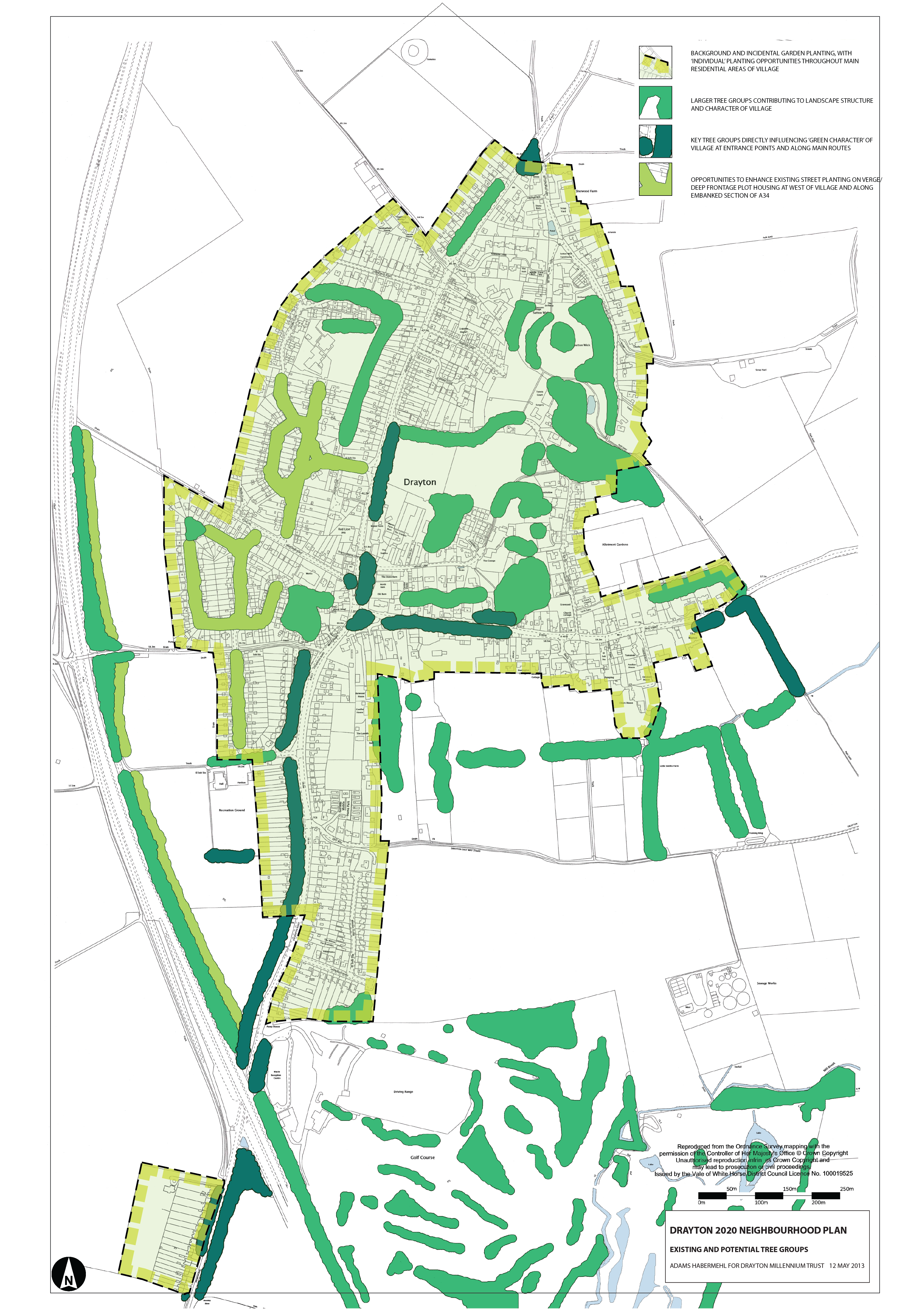
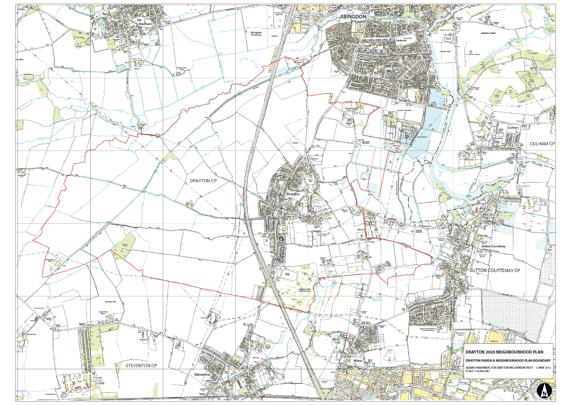
The following three plans were displayed and discussed at the Community Consultation event on 12th May 2013 in Drayton Community School:
Map 1 – Open Spaces Map
Map 2 – Tree Plan (Present & Possible)
Map 3 – Parish Map
Housing
Sustainability Assessment Scoping Report
The Drayton Neighbourhood Development Plan Sustainability Appraisal Scoping Report – Published 28 June 2013 is ‘work in progress’ and summarises the current position on evidence collected and required for the Drayton Neighbourhood Plan.
Statistical Profile
- A Rural Community Profile of Drayton
- Rural community profileDrayton – Age Structure – 2011
Biodiversity
Drayton Protected and Notable Species (Dec 2013). This species data has been supplied by Thames Valley Environmental Records Centre for the Drayton2020 Neighbourhood Plan. This data should not be used for any other purpose without permission of Thames Valley Environmental Records Centre especially for commercial use and to meet the requirements of planning applications. If wildlife data is required for planning applications please contact TVERC (www.tverc.org). The data should not be copied and supplied to any other organisation or person without permission of TVERC.
Bird Data from the British Trust for Ornithology (BTO) for the 2km square around Drayton (Grid Ref SU4794) for the years 2009 annually to 2013 can be found from Birdtrack at: http://blx1.bto.org/birdtrack/grid-refs/list-grid-species-new.jsp (Please Note you will need to register a new account with the British Trust for Ornithology, to access this data)
John Killick compiled a comprehensive picture of Drayton’s flora and fauna between 1990 and 2003 with the help of other volunteers. The files are available in the following links:
- Parish Nature Conservation Plan for Drayton
- Drayton Geology
- Records of mammals near Drayton
- The plants of Drayton
- Hedges – Drayton Parish
- The elms in Drayton parish
- Plants found in Drayton parish between 1995 and 2003
- Drayton outlying plant records to 2003
- Records of fungi in Drayton parish
- Drayton Copse
- Drayton Bryophytes (records by G Bloom)
- Records of birds near Drayton by Mike Wilkins in reservoir survey 1992
- Butterflies
- Records of birds in Drayton sent in by residents,
mostly April 2002 - Drayton Bird Survey 2001
- Drayton plants and fungi
- photofinal
Ecological work has also been carried out along the old Wilts-Berks Canal in Drayton:
- Comments by John Killick concerning proposals concerning the old canal (150/1/VALEPL/DEP01/9 and 150/9/L14/O)
- The Old Canal
The following documents give details of trees in Drayton mapped by Oxfordshire County Council (see also tree plan at top of this page)
- Drayton DK 01
- Drayton DK 01 Map 1
- Drayton DK 01 Map 2
- Drayton DK 01 Map 3
- Drayton DK 01 Map 4
- Drayton DK 01 Map 5
- Drayton DK 01 Map 6
- Drayton DK 01 Map 7
- Drayton DK 01 Map 8
The proposed housing development site South of High Street, Drayton has been surveyed by David Guyencourt (ABNATS):
- Drayton South Estates C Jan 2014
- Drayton South Estates B – Oct 2013
- Drayton Estates South B – Oct 2013
- 2014 07 Swifts Martins and Swallows in Drayton
- Map
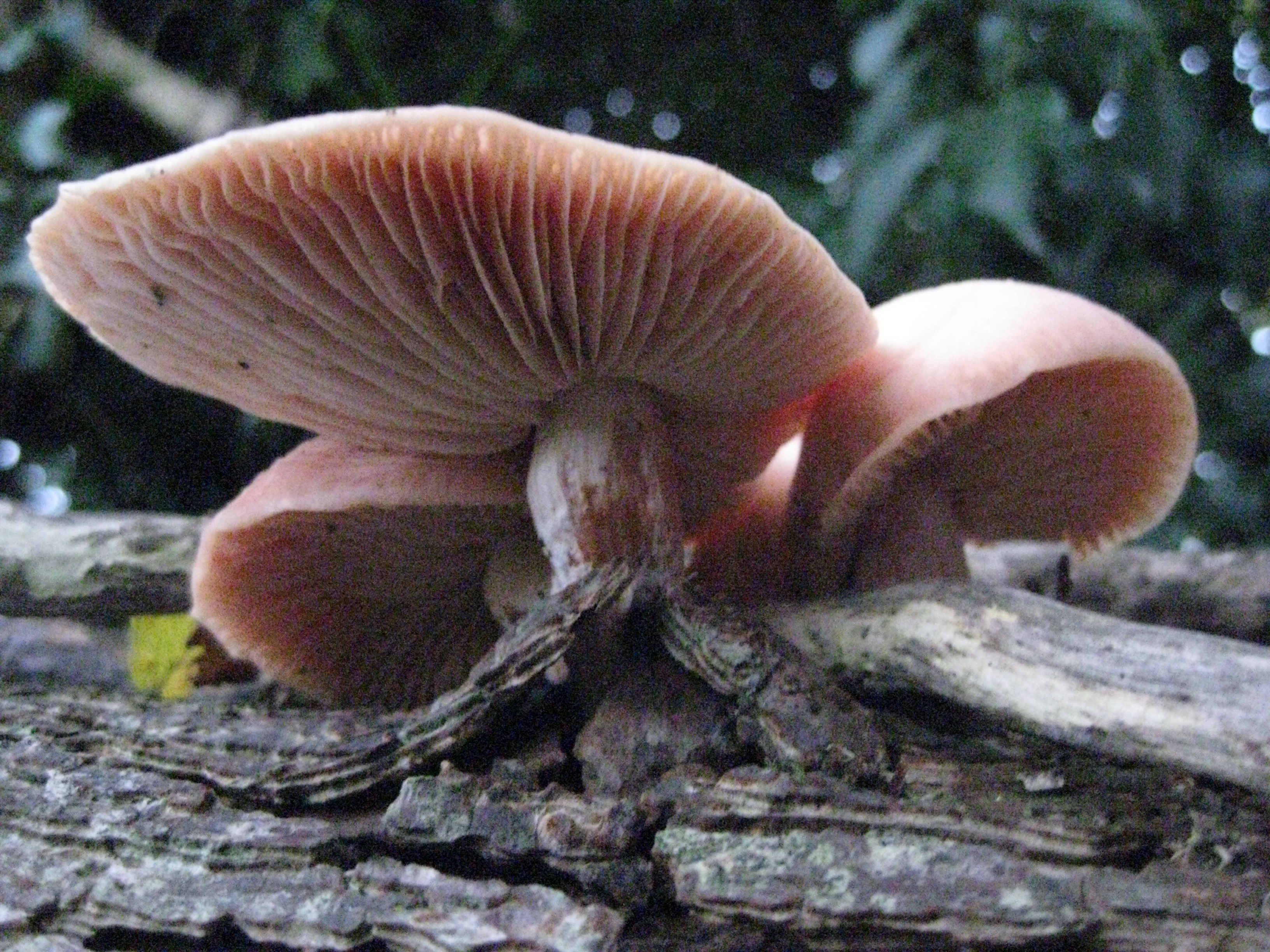
Rhodotus Palmatus – Grows on dead elm (South of High Street)
Previous Surveys of Drayton
Cllr Richard Webber conducted an informal house to house survey in 2008 and the results are summarised here
Village Appraisal
A copy of the 1982 Village Appraisal
Conservation Area
Three documents relating to the designation of the Drayton Conservation area:
- VWHDC report to planning committee 1990
- informal officer comments
- Manor Farm Contextual Character Appraisal Draft 1 02 08 2013
1998 03 04 Planning Inspectors Decision – Manor Farm
History and Archaeology
Drayton has a number of important listed buildings: English Heritage – Listed Buildings and Monuments 2013
Mediaeval St Peter’s Church
See: http://www.berkshirehistory.com/churches/drayton.html
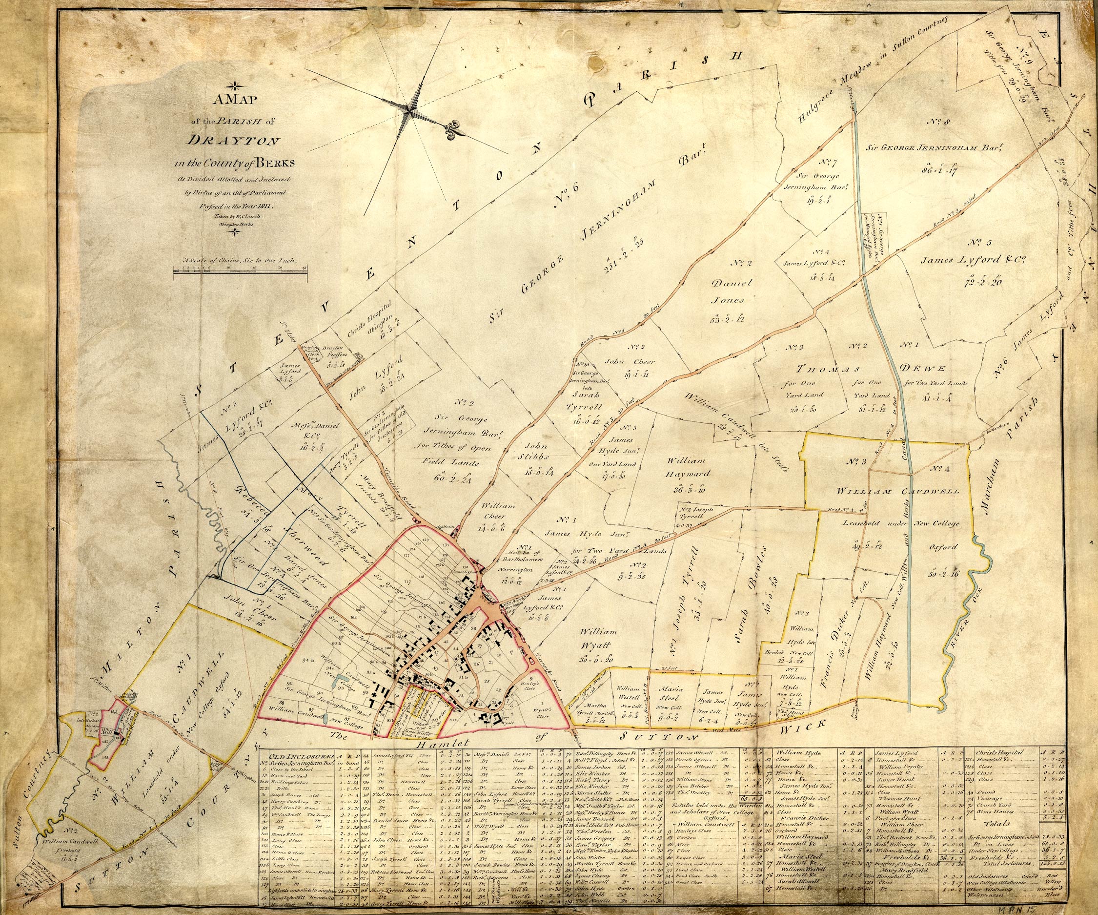
The 1815 Enclosure Map
There are also a number of important archaeological sites:
- Time Team excavated a site containing a unique set of Saxon Halls, probably the capital of the West Saxons, on part of the Brook Farm site. The programme can be viewed on YouTube: http://www.youtube.com/watch?v=4VOF2U3SYjc
The following archaeological map and reports on this site are available:
- Brook Farm Site HLE_A4L_NoGrade_HLE_A3L_NoGrade
- http://www.channel4.com/programmes/time-team/articles/sutton-courtenay-dig-report
- 71505_TT Sutton Courtenay
The Drayton Cursus, which dates from 2900 BC:
- http://megalithix.wordpress.com/2008/10/02/drayton-cursus-abingdon-oxfordshire-cursus/
- Excavations on the Cursus at Drayton Ainslie
Other archaeological sites include:
Walnut Meadow (Miller Homes) Site
779009 Land at Abingdon Road Drayton excavation report – client draft
South of High Street (Bloors) housing development site
Archaeology Report – South of High Street
The Wilts and Berks Canal
It is disused but is currently being restored, runs through Drayton. The following links and documents give information on the Canal:
- The Canal Restoration Trust website: http://www.wbct.org.uk/
- potted history on Wikipedia: http://en.wikipedia.org/wiki/Wilts_%26_Berks_Canal
- Long Distance footpath designation: Wilts and Berks Canal Towpath – Long Distance Footpath designation
and specifically on the Drayton and Abingdon stretch:
- A photo of Drayton Lock: Drayton Lock SU4594
- A description and photos from the Abingdon Blog: Berks & Wilts Canal – Abingdon Blog
- Notes on the Eastern End of the Canal
Relevant Planning Policies
- Vale of White Horse District Council’s draft Local Plan:
- Oxfordshire County Council’s third Local Transport Plan
- Science Vale UK website (Science Vale UK strategy)
- Science Vale UK website: http://www.sciencevale.com
- Local Enterprise Partnership website
- South Oxfordshire District Council’s Core Strategy – for general information on SVUK as it spans South Oxfordshire and Vale of White Horse District Areas: